
Weather
The hazy, hot and humid weather continues to end the week
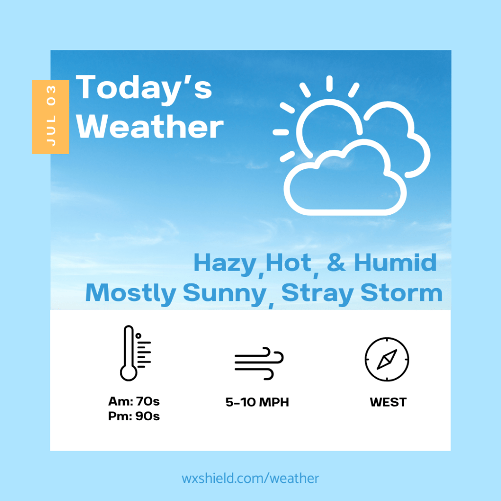
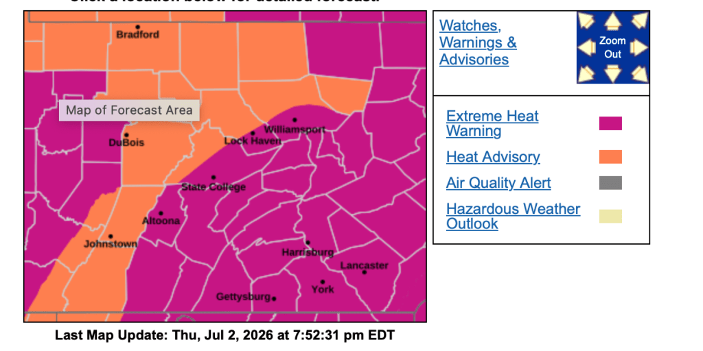
Good morning! I hope you are staying safe in this heat! We will continue to be hazy hot and humid on Friday. The Heat Advisories and Extreme Heat Warnings continue on Friday.
This morning temperatures will start in the 70s. We will have a clear sky to start our day. Winds will be from the west between five to ten mph.
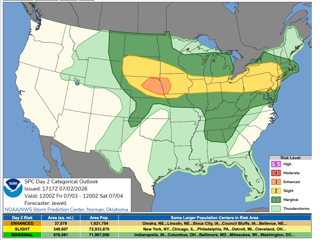
This afternoon will be hazy, hot, and humid. We will have a sunny to partly cloudy sky. A stray gusty storm cannot be ruled out. The National Weather Service has put us under a slight risk of severe weather. Temperatures will soar. into the upper 90s. Winds will be from the west between five to ten mph.
Tonight there could be a shower or storm around. It will be a humid night with patchy clouds. Low temperatures will be in the 70s.
Saturday for Independence Day, we will have high temperatures in the upper 80s to lower 90s. Winds will be from the west northwest between five to ten mph. We will have a mix of clouds and sunshine. Saturday afternoon into Saturday night we will have some natural fireworks with scattered storms. Saturday night temperatures will be in the lower 70s.
Click here for your full 4th of July weekend forecast.
Have a wonderful holiday weekend!
Almanac for today (Altoona records since 1948):
Average High: 83°F
Average Low: 62°F
Average Precip: .11″
Record High: 97°F in 1966
Record Low: 47°F in 2001
Record Precip: .94” in 1978
Yesterday’s High: 93°F
Yesterday’s Low: 72°F
Yesterday’s highest wind speed: WSW 13 mph
Sunrise: 5:48 am
Sunset: 8:47 pm
4th of July weekend will be humid with some storm chances
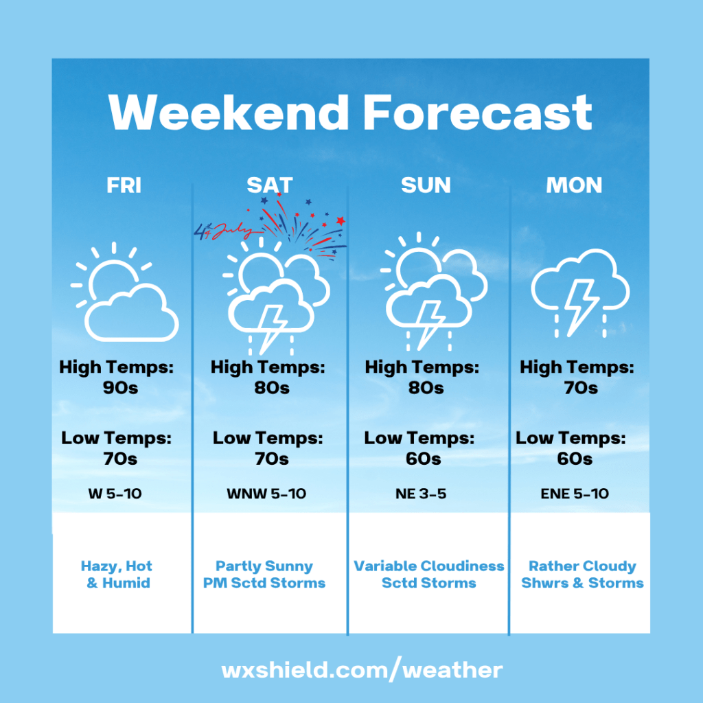
Good evening! I hope you are staying safe in this heat! We will continue to be hazy hot and humid on Friday. The Heat Advisories and Extreme Heat Warnings continue on Friday.
Friday temperatures will start in the 70s. We will have a clear sky to start our day. Winds will be from the west between five to ten mph.
Friday afternoon will be hazy, hot, and humid. We will have a sunny to partly cloudy sky. A stray gusty storm cannot be ruled out. The National Weather Service has put us under a slight risk of severe weather. Temperatures will soar. into the upper 90s. Winds will be from the west between five to ten mph.
Friday night there could be a shower or storm around. It will be a humid night with patchy clouds. Low temperatures will be in the 70s.
Saturday for Independence Day, we will have high temperatures in the upper 80s to lower 90s. Winds will be from the west northwest between five to ten mph. We will have a mix of clouds and sunshine. Saturday afternoon into Saturday night we will have some natural fireworks with scattered storms. Saturday night temperatures will be in the lower 70s.
Sunday high temperatures will be in the lower 80s. Winds will be from the northeast between 3-5 mph. Sunday we will have a variable cloudy sky with a few storms. Sunday night temperatures will be in the upper 60s.
Monday we will have a cloudy day with scattered showers and storms. High temperatures on Monday will be in the mid to upper 70s. Winds will be from the east and will be light. Monday night temperatures will be in the upper 60s.
Have a wonderful holiday weekend!
Almanac for today (Altoona records since 1948):
Average High: 83°F
Average Low: 62°F
Average Precip: .11″
Record High: 97°F in 1966
Record Low: 47°F in 2001
Record Precip: .94” in 1978
Yesterday’s High: 93°F
Yesterday’s Low: 72°F
Yesterday’s highest wind speed: WSW 13 mph
Sunrise: 5:48 am
Sunset: 8:47 pm
The scorching heat continues
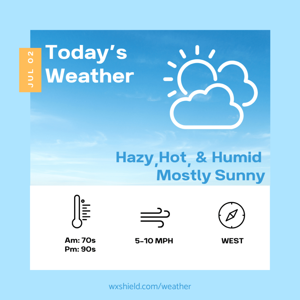
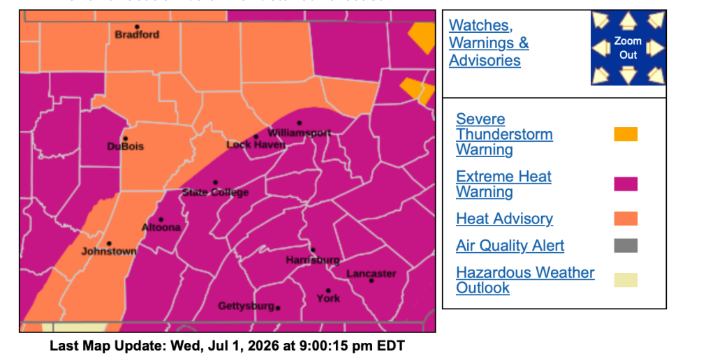
Good morning! It is going to be another hot hot hot day. Due to this, the Heat Advisories and Extreme Heat Warnings continue for our area. Please stay cool and hydrated and same with your pets!
Temperatures this morning will be in the lower to mid 70s. Winds this morning will be from the west between five to ten mph. We will have a clear sky.
This afternoon temperatures will be in the mid to upper 80s. With the humid air, it will feel above 100. Winds will be from the west between five to ten mph. This afternoon we will have hazy sunshine.
Tonight will be mainly clear and muggy. Low temperatures tonight will be in the mid 70. Winds will be from the west between five to ten mph.
Almanac for today (Altoona records since 1948):
Average High: 82°F
Average Low: 62°F
Average Precip: .11″
Record High: 97°F in 1966
Record Low: 44°F in 2001
Record Precip: 1.36” in 1993
Yesterday’s High: 92°F
Yesterday’s Low: 72°F
Yesterday’s highest wind speed: W 13 mph G 18 mph
Sunrise: 5:47 am
Sunset: 8:47 pm
 Wx Shield